

Old West Town Maps – Sanborn Maps
Accurate maps of towns and cities and the old west are somewhat difficult to find. Many of the historical archives contain bird’s eye maps of significant sites. However, fewer sites contain actual maps of the towns. As I was searching around, I came across several plat maps from the Sanborn Company. Apparently, Sanborn was a mapping company that started shortly after the end of the Civil War. The primary product were fire risk maps.
Sanborn operated from 1867-2007 with maps from over 12,000 locations. My particular interest is the era from 1860 – 1890 but others may be interested in the maps from more modern eras. Many of the older maps have passed into the public domain and archived by several national and state organizations. Check the external links section on the Sanborn Maps Wikipedia article for a good list of organizations.
Continue reading »
Grand Original Map Contest is Live
The time for dropping hints is over. The contest has officially launched over at Tenkar’s Tavern. Erik has kindly offered to host the contest and act as a judge along with Master Mapper Dyson, and yours truly.
You can snag all of the maps on this Google Drive folder or from the contest post. While the original maps are the prizes in the contest, anyone can utilize the images under the Creative Commons CC BY-NC-SA license — do what you will as long as its non-commercial.
For those who wish to view the rules in a non-blog setting, you can get snag the Google document.
Now get to creating. I’m going to get to slacking until I have to read all the great entries. All entries must be posted by Feb. 16th.
Contest Map Preview
This morning, I received the 5 digital images of the original Dyson Logos maps up for grabs in the impending contest. Four of the original hand-drawn maps will be given away — the digital variants will be used during the contest.
I did a bit of manipulation on the images to clean out edge artifacts and add sharpness using Matt Jackson’s new tutorial. The released images have been reduced by 50%. Once I’m happy with the originals, I will release the full resolution images. The final images will likely feature a Creative Commons license to maximize their usefulness to the community.
As noted previously, Dyson, Erik Tenkar, and myself will be judging the contest, which will run approximately a month. Full contest details should be available early next week. The map names are direct copies of Dyson’s naming scheme but likely have no bearing on what will end within the delves.
Enjoy the preview.
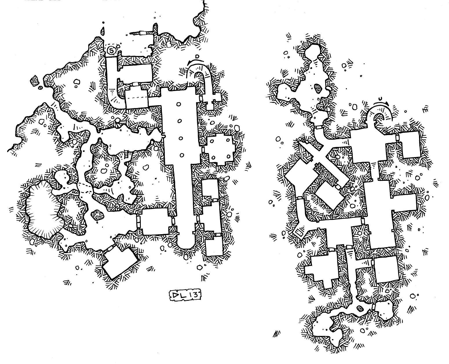
Dwarven Fortress

Torvek’s Tower

Rose River
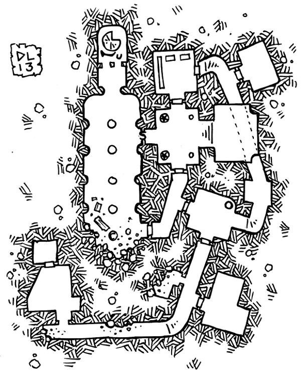
Count Michaels Ruins
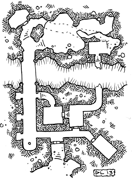
Troll Chasm
Labelled Grid Maps
When you are sitting at a table, it is quick and easy to get clarification on a map. You can just point to a specific point or indicate a region. The GM repeats the process. Maps are more difficult in a play-by-post situation. Everyone is reliant on a textual description to place objects unless the GM has the time to update and post a new map as action occurs. Graphical updates can be time consuming. Enter the labelled grid map.
The current PBP game I am in started with this map:

Nothing wrong with it but as the action flowed along, I began to lose track of where people, creatures, and pertinent objects were in the scene. Asking for clarification helps but doesn’t eliminate all the uncertainty. To aid in the process, you need a common method of describing positions. Something more specific than 9 directions or sides.
Enter mapping based on a grid system with labels.

I had no scale for reference from the original map. Scale isn’t required but is useful. I just fit a reasonably sized grid over the top of the original map and labelled both axes. Now I can specify exactly which grid cell my character is in by stating the X,Y labels in addition to the description. The GM, in turn, can position objects in a similar manner. Both of us have a much clearer understanding of where things are positioned. The labels mitigate confusion from text based descriptions.
The example grid was generated using the Pattern/Grid plugin for Gimp. Then I just added text labels along the axis of the map. Next time, I might figure out how to align the labels.
Map Scraps
Time to go back to hand drawn maps. They are easier to generate and just as functional. None the less, here’s a hack at a farm.

Yea Ole Farm with Issues
I have use for it but I could have spent a lot more time being creative rather than failing at mapping.
Clowning around with Maps
Like many people, most of my map are hand sketched atop graph paper with a focus on functionality over form. Since the RPG Blog Carnival is focused on cartography, I decided to knock the digital dust bunnies off my copy of Campaign Cartographer. I pretty much suck at CC3 mapping. Although I did learn a bit more about layering and object manipulation. So I’ll call it a marginal success.
Every carnival needs a clown.

Rough Layout of Merakai
I also did a quick and dirty dungeon style map of a burrow. It doesn’t really fit with the original idea I had but its a map. I was intending to do a side view style map but cannot get the ground layer to appear even marginal. Marginal is successful for me. This one has text labels in CC3. They look fine right up until you export the map and crop it. I knew that. Rather, I remembered right after cropping the exported image. Maybe this time I’ll remember to not bother and just insert labels, when needed, with Gimp.

Burrow Map
| M | T | W | T | F | S | S |
|---|---|---|---|---|---|---|
| 1 | 2 | 3 | 4 | 5 | ||
| 6 | 7 | 8 | 9 | 10 | 11 | 12 |
| 13 | 14 | 15 | 16 | 17 | 18 | 19 |
| 20 | 21 | 22 | 23 | 24 | 25 | 26 |
| 27 | 28 | 29 | 30 | 31 | ||
Popular Resources
Categories
- Brewing (11)
- Code (111)
- Convergence (26)
- Game Design (4)
- Hovel (1)
- Labyrinth Lord (71)
- Maintenance (9)
- Merakai (15)
- Musings (199)
- Old School (100)
- Random Generator (17)
- RPG (404)